Where the SN Met the Bay Point and Clayton at Clyde

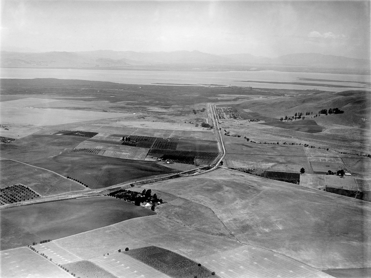
High above the Concord border at Ohmer and heading north in the late 1920s, George Russell captured the town of Clyde in the distance and very much more. See the further detail next. Ref: 165 API 563_5_BOX 59
L132-05-George Russell Photo, Courtesy California State Lands Commission, Detail , (Image 1 of 16)

A detail from L132-05, this north view contains enough historical markers and information to fill volumes. See the annotated version next to get started. Ref: 165 API 563_5_BOX 59
L132-10-George Russell Photo, Courtesy California State Lands Commission, Detail , (Image 2 of 16)

An annotated version of L132-10, north view from the late 1920s. The red circle encompasses the topic for this presentation, the crossing of the SN and Bay Point and Clayton Railroad. Ref: 165 API 563_5_BOX 59
L132-11-George Russell Photo, Courtesy California State Lands Commission, Detail , (Image 3 of 16)

Now ahead to 1944, a west view panorama along the Arnold Industrial Highway, the SN and Bay Point and Clayton can be seen converging on Clyde from the south. See the next detail for a better view. The land to the left or south of the highway will soon become the north border of the Concord Naval Weapons Station Inland Area. Ref: RG 181 1944 N1-13NT1-32Serial38436 083144
L132-15-US Navy Photo, Courtesy the National Archives of San Francisco, (Image 4 of 16)

A detail of L132-15 shows the Bay Point and Clayton along the lower edge crossing the Arnold Industrial Highway, while the SN bridge over the highway is seen toward the middle of the frame. Ref: RG 181 1944 N1-13NT1-32Serial38436 083144
L132-20-US Navy Photo, Courtesy the National Archives of San Francisco, (Image 5 of 16)

Further to the north, the SN, yellow arrow, and Bay Point and Clayton, orange arrow, begin converging on Clyde through farmland today occupied by the Diablo Creek Golf Course. Note the Clyde Hotel along the right edge of the west view, 1944. Ref: RG 181 1944 N1-13NT1-32Serial38436 083144
L132-25-US Navy Photo, Courtesy the National Archives of San Francisco , (Image 6 of 16)

No images of a Bay Point and Clayton train in the act of crossing the SN track has been found. Here in this south view from 1940 with Mt. Diablo as a back drop, a Baldwin 0-6-0 led train heads back from Bay Point to the Cowell Portland Cement Co., the owners of the Bay Point and Clayton. The SN’s overhead catenary is an unequivocal marker for the crossing.
L132-30-Sappers Collection, Courtesy BAERA, Western Railway Museum Archives, 79490bpc, (Image 7 of 16)

Dudley Thickens northwest image from Apr. 2, 1939 of Bay Point and Clayton Baldwin 0-6-0 no. 2 comes the closest to an actual train crossing the SN. The catenary wire tells us that the train is either ready to cross or is on the interchange track. This image was from the Northern California Railroad Club excursion from San Francisco to the Cowell Portland Cement Co.
L132-35-Dudley Thickens Photo, Courtesy BAERA, Western Railway Museum Archives, 98597bpc, (Image 8 of 16)

The majority of passenger era images of SN trains crossing the Bay Point and Clayton right-of-way surviving today were taken when elimination of SN passenger service on the south end was imminent. This view from June 22, 1941 of SN 1014 shows some of the features south of the crossing including Mt. Diablo and the Port Chicago Highway.
L132-40-Dudley Thickens Photo, Courtesy BAERA, Western Railway Museum Archives, 94738sn, (Image 9 of 16)

Another south view, here showing more of the area to the west of the SN track, was taken 8 days later on the last Sunday of passenger service, June 29, 1941, with SN 1014, SN 1005 and the Bidwell parlor car.
L132-45-Louis Bradas, Jr, Photo, Courtesy BAERA, Western Railway Museum Archives, 68183sn, (Image 10 of 16)

Now turning 180 degrees to the north of the crossing and the second to the last unscheduled SN passenger run, July 5, 1941. SN 1014 has completed its stop at the Clyde shelter and stops at the crossing in deference to its senior neighbor. Note the isolated box car on an interchange track.
L132-50-Richard Jenevein Photo, Courtesy BAERA, Western Railway Museum Archives, 98559sn , (Image 11 of 16)

Images of the crossing from before 1941 are rare, and this one taken at a northwest angle shows the trio of SN 1011, SN 1008 and SN 228 at Clyde on Aug. 3, 1940.
L132-55-Sappers Collection, Roy Covert Photo, Courtesy BAERA, Western Railway Museum Archives, 97697, (Image 12 of 16)

This undated north view shows details of the Clyde shelter, sharing with a few other Contra Costa County shelters the placards indicating the mileage to and from the two south-end termini.
L132-60-Courtesy BAERA, Western Railway Museum Archives, 98558sn, (Image 13 of 16)

A rare view down the Port Chicago Highway in 1941, south of the crossing, with a car heading south and the northbound crossbuck in full view.
L132-65-Sappers Collection Courtesy BAERA, Western Railway Museum Archives, 98594sn, (Image 14 of 16)

The End-of-an-Era excursions of April 12, 1964 also graced the crossing, marking the passage of the SN right-of-way between Walnut Creek and Concord for phase 1 of BART construction. However, Clyde would not be considered as a destination for eventual extension of BART to Pittsburg-Bay Point. More on this later.
L132-70-Tony Perles Photo, Courtesy BAERA, Western Railway Museum Archives, 85024sn, (Image 15 of 16)

The Clyde railroad crossing made it possible for students to transfer between rail lines as seen in this southeast view of SN 1001 and trailer from May 29, 1940. After 1941, however, it became more renown as a transfer point for other purposes as the next landmark will reveal.
L132-75-Courtesy BAERA, Western Railway Museum Archives, 98566sn, (Image 16 of 16)