Was that Photo Taken at Clyde?

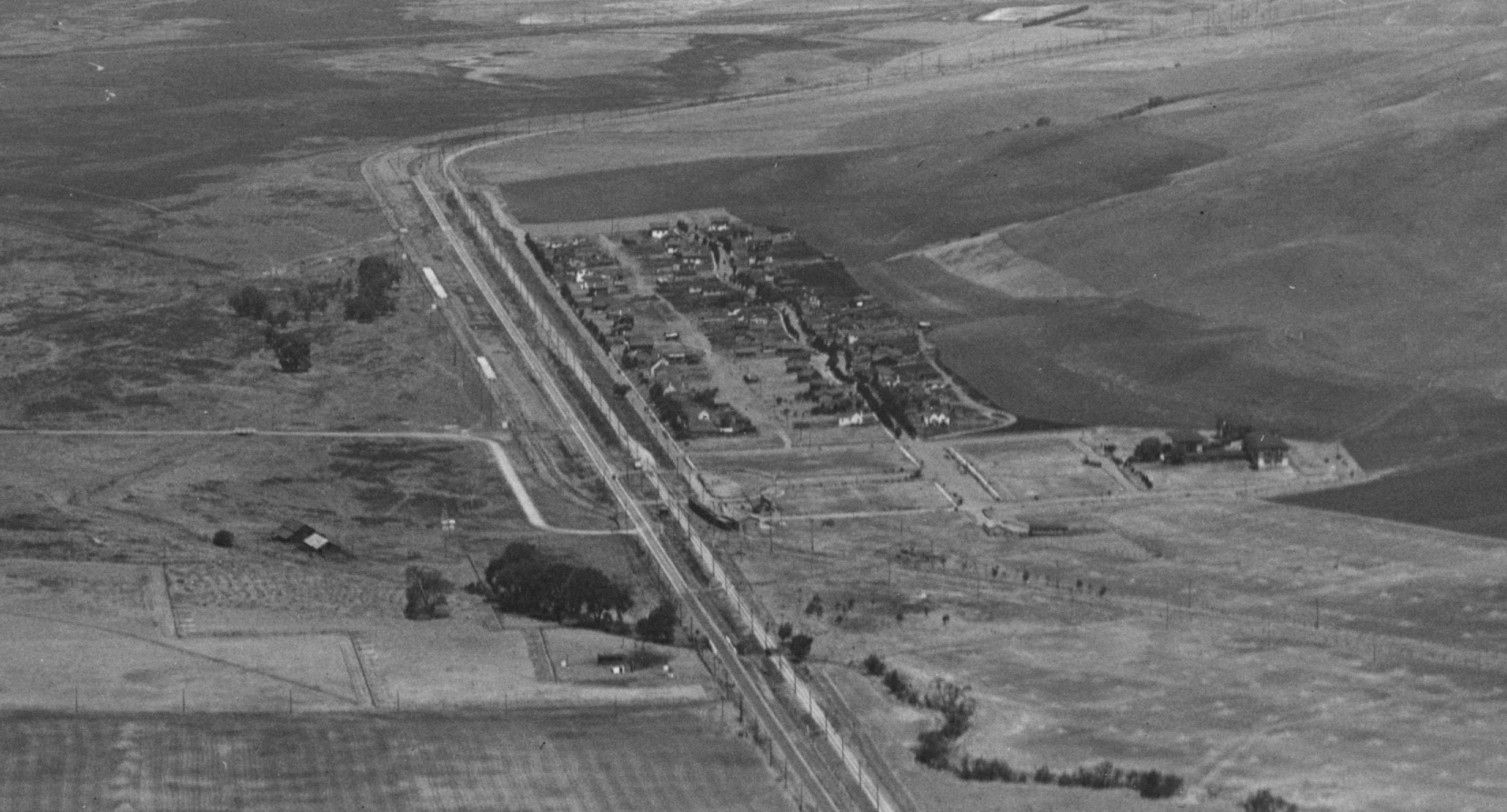
Aerial images such as this north view circa 1929 from George Russell provide a very clear layout of the town of Clyde. Ref: API 563_6_BOX 59113
L134-01-George Russell Photo, Courtesy California State Lands Commission, Detail , (Image 1 of 15)

Unfortunately, images documenting more of the day-to-day life and details of this area have been hard to come by save this undated south view backed by Mt. Diablo.
L134-04-Courtesy BAERA, Western Railway Museum Archives, 97697sn, (Image 2 of 15)

A majority of photos after the passenger era such as this northeast view from Jan 13, 1957 of SN 1005 and Salt Lake and Utah 751 on an excursion included some obvious marker to make the location unequivocal. But the exact location of the “Clyde” sign does not correspond to that prior to WWII.
L134-05-Arthur Lloyd Photo, Courtesy Arthur Lloyd , (Image 3 of 15)

Same place and time as L134-05, but this image documents that the “Clyde” sign in later years was moved from the south to the north of the Bay Point and Clayton crossing, and the passenger-era shelter was replaced by a simpler structure that was placed north of the block signal.
L134-10-Roy Proffer Photo, Courtesy BAERA, Western Railway Museum Archives, 98600sn, (Image 4 of 15)

The grade crossing with car seen in the background of L134-10 is the same crossing as in this east image of SN 653, but the unequivocal landmark allowing assignment of the location is the Clyde Hotel in the background.
L134-15-Clyde, SN 653, Tom Gray Photo, Courtesy Tom Gray, (Image 5 of 15)

This set of northeast, left, and southeast, right, images of SN 605 switching freight circa 1950 would be orphans if not for the portion of the Clyde Hotel seen in the background of the right image.
L134-20-Norman Smith Photos, Courtesy BAERA, W. Railway Museum Archives, 98579.1, l, 98579.2, r, (Image 6 of 15)

The sign may say Port Chicago, but the portion of the same hotel allows this northeast view from Dec. 1953 to be placed south of the Bay Point and Clayton crossing.
L134-25-Moreau Collection, Courtesy BAERA, Western Railway Museum Archives, 100998.1 , (Image 7 of 15)

The sign in this north view circa 1950 does reveal the Naval Magazine is near, but the “Atlas” on the sign indicates this is Clyde, home of the Atlas Framing Company
L134-30-Tom Gray Photo, Courtesy Tom Gray , (Image 8 of 15)

The combination of the shelter, the block signal and the hills to the northeast indicate it is circa 1950 in Clyde, north of the Bay Point and Clayton grade crossing. Of course, MW 302 had just received a make-over in mid-1954, and this image is from one of two possible excursions that took place at that time. The building in the background, right ...?
L134-35-Tom Gray Photo, Courtesy Tom Gray, (Image 9 of 15)

... based on this northeast view from the same excursion is “...arner Co.”. Rich Bentley discovered that the 1950 Contra Costa phone directory has a listing for the Van Warner Company at 309 Main, phone #40. No information has been uncovered on the products or services of this business.
L134-40-Roy Proffer Photo, Courtesy BAERA, Western Railway Museum Archives, 98599sn , (Image 10 of 15)

Many copies of this northeast view of MW 302 from the Sept. 12, 1948 BAERA excursion can be found, but no one seemed to know where photos such as this one were taken.
L134-45-Tom Gray Photo, Courtesy Tom Gray, (Image 11 of 15)

Thank goodness Addison Laflin took many shots of the same event from different angles, and, when the backgrounds are combined with those from Tom Gray’s shots on either side of MW 302, presto, a northeast view of Clyde north of the shelter appears.
L134-50-Courtesy Tom Gray and Addison Laflin Photos, Courtesy BAERA, WRM Archives, 100595-602sn, (Image 12 of 15)

The SN right-of-way north of the shelter remains intact, seen from a south view, left, and a north view, right, from the location of the block signal left from the SN era in this area. This location can be compared to the placement of the signal as seen in L134-04.
L134-55-Stuart Swiedler Photos, (Image 13 of 15)

Today upon reaching the northern border of Clyde, the Port Chicago Highway is closed, reflecting a decision made by the Navy in 1995. What was once the SN track starts up north of the guard station. The subject of Clyde will return in the History section both in terms of its role in formation of Pacific Coast Ship Building and in war.
L134-60-Stuart Swiedler Photo, (Image 14 of 15)

SN 654 heading north, south view, circa 1950.
L134-65-Robert P. Townley Photo, Courtesy Robert P. Townley, (Image 15 of 15)