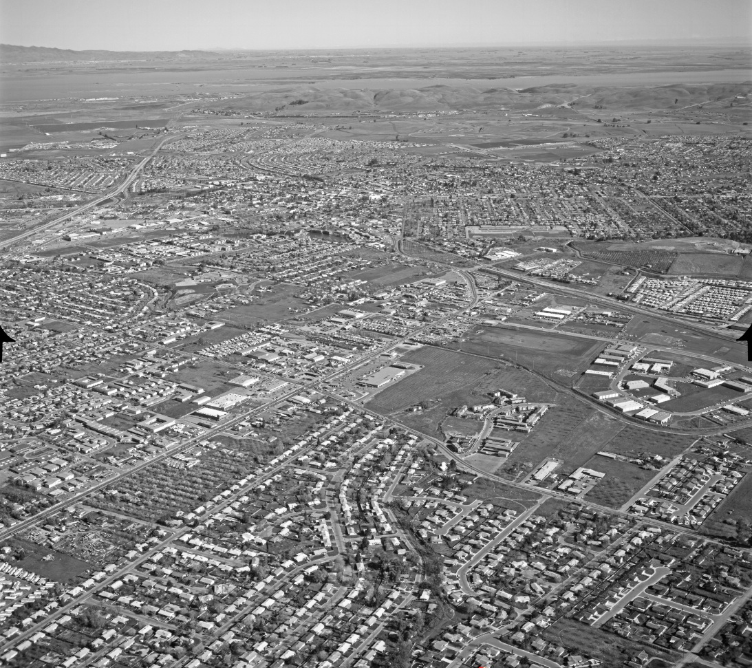
The Gentle Curve of Monument Boulevard

This landmark will follow Monument Blvd., known during the SN’s electric days as Monument Rd., as seen in this northeast panoramic view of Concord from Mar. 3, 1969. Detail to follow.
L126-05-Copyright California Department of Transportation, 15606-37, (Image 1 of 20)

A detail from L126-05, a northeast view from Mar. 3, 1969, shows Monument Blvd. turning along St. Stephen’s Cemetery, curving along the SN right-of-way, and diverging from the rails to become Galindo St. at Cowell Rd., the latter known as Ynez Ave. during the SN’s electric operation.
L126-10-Copyright California Department of Transportation, 15606-37, Detail, (Image 2 of 20)

A northwest view of the same area as in L126-05, Mar. 3, 1969, as well as the SN route into central Concord.
L126-15-Copyright California Department of Transportation, 15606-40 , (Image 3 of 20)

Now a southeast view circa 1956, where the SN first parallels St. Stephen’s Cemetery, then Monument Rd. Ref: brk00017177_24a
L126-20-Clyde Sunderland Photo, Courtesy of The Bancroft Library, University of California, Berkeley, (Image 4 of 20)

Annotated version of L126-20. Important SN markers for subsequent images include the trestle over Galindo Creek, yellow arrow, catenary pole with mile 33 marker, white arrow, and pole with extra supporting pole, black arrow. The names of the short street segments, red and blue arrows, have not been determined. Ref: brk00017177_24a
L126-21-Clyde Sunderland Photo, Courtesy of The Bancroft Library, University of California, Berkeley, (Image 5 of 20)

Mount Diablo looms large in this southeast viewed image from the Apr. 12, 1964 End-of-an-Era excursion, as Concord-bound SN 143 has guided its passenger cars across the San Miguel Rd. grade crossing, the crossbuck of the latter seen in the distance.
L126-25-Tony Perles Photo, Courtesy BAERA, Western Railway Museum Archives, 85028sn, (Image 6 of 20)

SN 143 and passenger load, again from the Apr. 12, 1964 End-of-an-Era excursion, this time along side the cemetery on its return to Walnut Creek in a northeast view.
L126-30-Courtesy Charles Smiley, (Image 7 of 20)

SN 1005 and SN 1023 as train 27 approach the Galindo Creek trestle on route to Oakland on June 8, 1941 in this northwest view.
L126-35-Vernon Sappers Collection, Courtesy BAERA, Western Railway Museum Archives, 94742sn, (Image 8 of 20)

Now for the curve along Monument Rd., seen from a northeast view circa 1952 with SN 670 and freight heading to Walnut Creek. Note the businesses at the intersection of the road with what is today Oakmead Dr., but at that time Palindo Ave. Note the pole with the extra supporting pole as seen in L126-21.
L126-40-Norman Smith Photo, Courtesy BAERA, Western Railway Museum Archives, 55557.1sn, (Image 9 of 20)

From a point north of L126-40, a similar northeast view of the curve along Monument Rd. circa 1952, but now SN 670 is at the rear pushing the freight closer to central Concord.
L126-45-Norman Smith Photo,Courtesy BAERA, Western Railway Museum Archives, 55603sn , (Image 10 of 20)

From a point north of L126-45, a freight with SN 652 and SN 653 offset by one car is seen in this northeast view. EK Muller chased this last west-bound train heading to Oakland, Feb. 27, 1957.
L126-50-EK Muller Photo, Courtesy BAERA, Western Railway Museum Archives, 90058sn, (Image 11 of 20)

Next, a series of three images from excursions with MW 302 at the Monument Rd. curve with both the extra supporting pole and mile 33 sign markers visible. All are from a southwest view starting with this one.
L126-55-Addison Laflin Photo, Courtesy BAERA, Western Railway Museum Archives, 94745sn., (Image 12 of 20)

Likewise, a similar southwest view taken further north relative to L126-55, July 4, 1950 with Salt Lake and Utah 751 as trailer to MW 302.
L126-60-Tom Gray Photo, Courtesy Tom Gray , (Image 13 of 20)

And the last one, here showing a windmill across the road, southwest view, also July 4, 1950.
L126-65-Al Thoman Photo, Courtesy BAERA, Western Railway Museum Archives, 35921sn, (Image 14 of 20)

SN 660 is captured in this circa 1940 southwest view approaching the grade crossing where the extension of Galindo St. meets Cowell Rd., then Ynez Ave.
L126-70-Paul Smith Photo, Courtesy BAERA, Western Railway Museum Archives, 94233sn , (Image 15 of 20)

Housing development in the area can be documented matching the large tree in the background of this circa 1950 southwest view of MW 302 on a rail fan excursion with the same one in L126-70.
L126-72-Vernon Sappers Collection, Courtesy BAERA, Western Railway Museum Archives, 94743sn, (Image 16 of 20)

Now viewed from the grade crossing, SN 661 can be seen returning passenger cars to Chico, July 1, 1941, southwest view.
L126-75-Courtesy BAERA, Western Railway Museum Archives, 72394sn , (Image 17 of 20)

Compare this southwest view of SN 670 at the grade crossing circa 1952 with the previous L126-75 and the evidence for the housing boom can be seen both across Monument Rd. and in the distance.
L126-80-Norman Smith Photo, Courtesy BAERA, Western Railway Museum Archives, 71847.6sn, (Image 18 of 20)

The last of the southwest views at the grade crossing with SN 653. Compare this to the previous image to convince yourself that this post-WWII picture was taken earlier in time.
L126-85-Dave Gumz Photo, Courtesy BAERA, Western Railway Museum Archives, 94234sn, (Image 19 of 20)

Only one southeast view of this intersection was found, here documenting a Concord-bound freight with SN 603 and 604. Not a home or business in view in this image from Sept. 1946.
L126-90-Louis Bradas, Jr. Photo, Courtesy BAERA, Western Railway Museum Archives, 67947sn, , (Image 20 of 20)