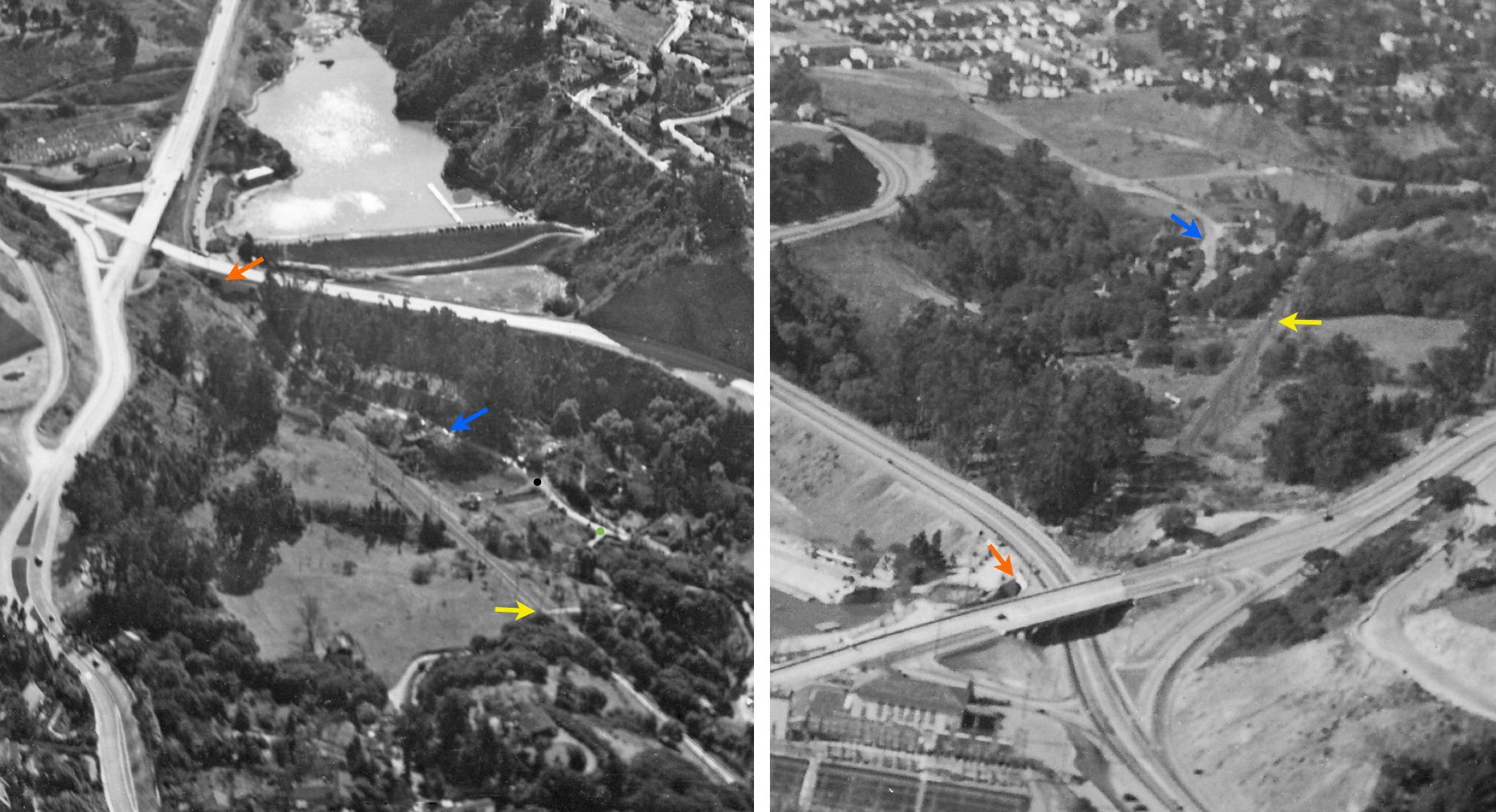
Temescal Cut and Marie Way

Two aerial views of Chabot Canyon circa 1940 looking southeast, left, and west, right, with Chabot Rd,. blue arrow, and its intersections with Roble Rd., green circle, and Marie Way, black circle. Temescal Cut referred to the segment bordered by the SN-Roble Rd. grade crossing to the west, yellow arrows, and the SN-Chabot Rd. underpass of Broadway to the east, orange arrows.
L68-05-Courtesy Oakland History Room, Oakland Public Library, (Image 1 of 18)

Now ahead to Aug. 27, 1956, as SN 660 and freight climb the grade by Marie Way in this west view. All the homes in the background were lost during the 1991 Firestorm. More details in “Missing from Chabot Canyon - Consumed by the Fire and Final Accounting” in the History section.
L68-10-Fred Matthews Photo, Anonymous Donor, (Image 2 of 18)

However, the next two images will allow a quick identification of what was seen on the previous image. First appreciate the white-roofed homes in this northwest view, with Broadway on the left, or south, and Tunnel Rd. on the right, or north. from Apr. 8, 1953.
L68-15-Copyright California Department of Transportation, 3301-19, Detail , (Image 3 of 18)

A complementary southwest view of the same scene from Apr. 8, 1953 with the roads reversed relative to the previous aerial view.
L68-20-Copyright California Department of Transportation, 3301-23, Detail , (Image 4 of 18)

Next for some earlier history. An earlier mid-1920s view of this area confirms that part of the SN right-of-way was derived from the Heimbold’s land, while the eastern portion utilized a previously constructed trail to the lake.
L68-25-Thomas Bros Block Book of Oakland, Courtesy Oakland History Room, Oakland Public Library, (Image 5 of 18)

The next three northwest images were produced by three different SN photographers from a BAERA excursion from Nov. 29, 1953 that utilized SN 644 to return MW 302 to Oakland. Although transmission towers are seen as well as a structure at the right edge, the many copies of this image remained unlabeled until now.
L68-30-Tom Gray Photo, Courtesy Tom Gray , (Image 6 of 18)

This second northwest image from Nov. 29, 1953 with SN 644 and MW 302 adds a tall tree to the right border, but little else.
L68-35-Arthur Lloyd Photo, Courtesy Arthur Lloyd, (Image 7 of 18)

A third northwest view from Nov. 29, 1953 with SN 644 and MW 302 now provides two homes and a light pole to what was seen previous.
L68-40-Norman Smith Photo, Courtesy BAERA, WRMA, 55613.1sn, (Image 8 of 18)

This view taken from the east end of Rockridge Curve shows the entire Chabot Canyon corridor and Temescal Cut from Aug. 25, 1949. This image confirms that the structure in the background of the three previous images corresponds to the Landvale Rd. Overpass.
L68-45-Vernon Sappers Collection, Courtesy BAERA, Western Railway Museum Archives, 68146sn, (Image 9 of 18)

As for the homes and light pole, this oblique view of Temescal Cut looking north from July, 1941 of SN 661 returning passenger cars to Chico provides the answer showing the homes and light pole in question as corresponding to Marie Way.
L68-50-David Merrill Photo, Courtesy BAERA, Western Railway Museum Archives, 43970sn, (Image 10 of 18)

A north view of the same area on Marie Way taken from Chabot Road in 2012.
L68-55-Stuart Swiedler Photo, (Image 11 of 18)

Newspaper accounts of the last freight heading east from Oakland on Feb. 27, 1957 describe how the train was split in two parts for SN 652 and 653 to bring the load up to Lake Temescal in the light rain. An image from this event in this east view just west of what can be confidently assigned as Marie Way.
L68-60-Enrique K Muller Photo, Courtesy BAERA, Western Railway Museum Archives, 45019sn, (Image 12 of 18)

Now on Broadway, Apr. 1939, a west view of the cut and Chabot Rd. As documented in the previous Landmark concerning the SN underpass, the sign along the rails in the foreground states “No Trespassing”, but the message on the one to the west is unknown.
L68-65-Vernon Sappers Collection, Courtesy BAERA, Western Railway Museum Archives, 68834sn, (Image 13 of 18)

Back at ground level on Chabot Rd., left, a three-car train led by SN 1003 continues up the grade past the mystery sign in this 1940 west view.
L68-70-Louis J Bradas, Jr. Photo, Courtesy BAERA, Western Railway Museum Archives, 67580sn, (Image 14 of 18)

SN 603 and SN 604 lead a freight with a flatcar with construction equipment and an open car with soil or ground product to the Broadway underpass in this northwest view from 1948.
L68-75-Roger Heller Photo, from the collection of the Moraga Historical Society, Moraga, CA, NN-60, (Image 15 of 18)

SN 1005 and SLU 751 parlor car take a break during the Jan 13, 1957 excursion trip prior to entering the Broadway underpass. The viewer-side window of 1005 typically depicted “X1005” on these trips, but removal of the BAERA banner and placement of a more traditional train number, number 16 here, were sometimes done to produce a passenger-era effect.
L68-80-Arthur Lloyd Photo, Courtesy Arthur Lloyd, (Image 16 of 18)

A SN 652-led freight and a car on Chabot Rd. head for the Broadway underpass in this 1950s northwest view. No images have been found showing that cars, versus those on foot, could enter Lake Temescal this way. Prior to building Broadway in the mid-1930s, Chabot Rd. was the only way for cars to reach the northwest side of the lake.
L68-85-Enrique K Muller Photo, Courtesy BAERA,Western Railway Museun Archive, 45000sn , (Image 17 of 18)

This east view of Temescal Cut to the Broadway underpass from Aug., 25, 1949 shows the written side of the mystery sign whose unwritten side appears in L68-50 and L68-55. The limits of resolution of this image have prevented a deciphering, so more work to do.
L68-90-Vernon Sappers Collection, Courtesy BAERA, Western Railway Museum Archives, 68830sn, (Image 18 of 18)