Now Leaving Eastport, the Next Stop is Wilcox

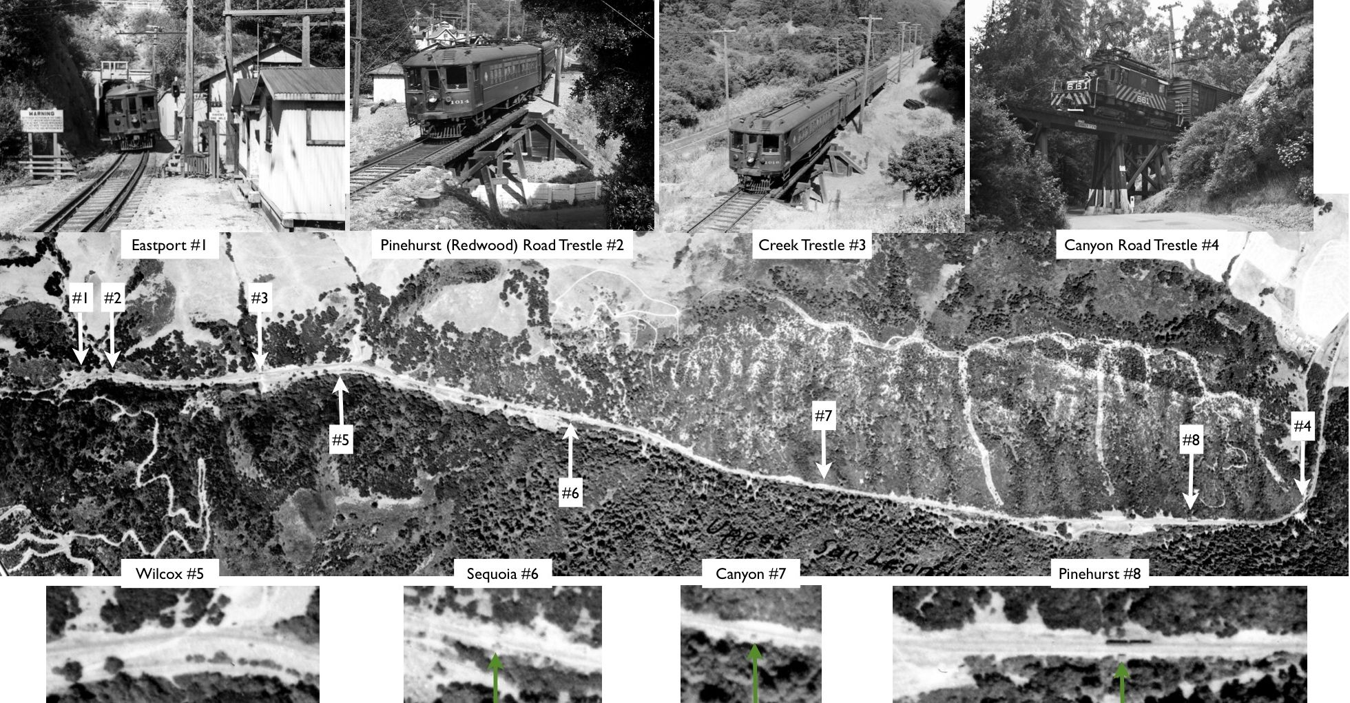
This section will begin to document the position of the four flag stops and other notable markers along Canyon’s course. The green arrows point to flag stop structures. The aerial and four lower inserts are from Jul. 30, 1939. Refer to “Trestles in the Trees” and "The Garden of Eastport” Landmarks for attributions of the upper four insert images.
L36-05-USDA, AAA, Western Division Laboratories, BUT BUU-283-80, Panel 79, Courtesy EBMUD, (Image 1 of 14)

From Eastport, this southeast view image of SN 603 and 604 approaching the trestle over Pinehurst Road in the 1940s reveals a marker eucalyptus tree to the left, or east of the right-of-way, and a stand of tall trees further southwest, or right of the road. The catenary wire poles shift to the east side of the track as the right-of-way begins its curve to the east, or left.
L36-10-Don Olsen Photo, Courtesy BAERA, Western Railway Museum Archives, 51824sn , (Image 2 of 14)

Heading down the canyon southeasterly, this undated image to the northwest shows a two car train at the end of a long straight away. The parallel road will be referred to by its name since at least the 1950s, Pinehurst Road, previously Redwood Canyon Road, Snake Road, and in some accounts, Colorado Road.
L36-15-Cheney Photo, B-1957, Sappers Collection, Courtesy BAERA, WRM Archives, 24170sn, (Image 3 of 14)

A detail from L36-15 shows a man in a suit just beyond the train, close to a path down to the road. The eucalyptus tree and the stand of tall trees noted in L36-10 provide relative position, as does the switch of the catenary poles from the west to the east side of the track at the curve in the distance.
L36-20-Cheney Photo, B-1957, Sappers Collection, Courtesy BAERA, WRM Archives, Detail 24170sn, (Image 4 of 14)

Eston Cheney eventually got down from the hill where he took L36-20 and captured this undated southwest view at track level. The significance of the pole adjacent to the two individuals is revealed in a detail shown next.
L36-25-Cheney Photo, B-1958-A, Sappers Collection, Courtesy BAERA, WRM Archives, 24171sn, (Image 5 of 14)

The detail from the undated southwest view L36-25 now shows the marker for the Wilcox flag stop, the first stop on the journey east from Eastport.
L36-30-Cheney Photo, B-1958-A, Sappers Collection, Courtesy BAERA, WRM Archives, 24171sn, (Image 6 of 14)

This southeast view from 1912 shows several key elements of the Wilcox flagstop area including the road up from Pinehurst Road and across the tracks to the McCosker Ranch. Other key elements are the switch of the position of the catenary poles near the curve in the background, and another key eucalyptus tree to the west of the road in the background.
L36-35-Courtesy BAERA, Western Railway Museum Archives. 52066sn, (Image 7 of 14)

The road from Pinehurst Road up to the tracks is seen in this northwest view from a June 1956 excursion. The road today is marked by a sign indicating the way to John McCosker Ranch Road. The access to the right-of-way made this a popular spot for SN photographers.
L36-40-Courtesy BAERA, Western Railway Museum Archives, 54978sn , (Image 8 of 14)

Another view of the same spot from circa 1950 shows a northwest view of SN 661 bringing military equipment through the canyon.
L36-45-Dave Gumz Photo, Courtesy BAERA, Western Railway Museum Archives, 59263sn, (Image 9 of 14)

As the passenger era comes to a close, SN 651 brings up the rear of this freight as it approaches the Wilcox flagstop, Jul 6, 1941, southeast view.
L36-50-Art Alter Photo, Paul Smith Collection, Courtesy BAERA, WRM Archives Archives, 59256sn, (Image 10 of 14)

Ahead to Feb. 11, 1950, SN 661 and 603 pull a long freight past the Wilcox grade crossing in the same southeast view, but the grade crossing sign is no more.
L36-55-Tom Gray Photo, Courtesy Tom Gray, (Image 11 of 14)

Just southeast of the flag stop, SN 1007 leads a two-car train to the mile 15 marker. This image documents its exact position relative to this set of catenary poles. The SN had several of these pole markers to complement those on the trestles and overpasses indicating the mileage from San Francisco.
L36-60-Courtesy BAERA, Western Railway Museum Archives, 17828sn, (Image 12 of 14)

From L36-05, the locations of the mile 15 marker, the 14 mile marker on the trestle over Pinehurst Road at Eastport, and the mile 16 marker at the trestle over Canyon Road suggest that the exact distances cannot be accurate given the relative distances or the length of the canyon. More information is wanting. Southeast view of SN 660 at dusk, circa 1948.
L36-65-Tom Buckingham Photo, Courtesy BAERA, Western Railway Museum Archives, 54297sn , (Image 13 of 14)

A little further southeast, this image of SN 1005 and Salt Lake and Utah parlor car 751 from a Jul. 6, 1956 excursion reveals the curve to the east and catenary pole shift to the west side of the track. Around the corner, the next stop, Sequoia station.
L36-70-John Harder Photo, Courtesy John Harder , (Image 14 of 14)