Missing From Chabot Canyon – Severing Severance
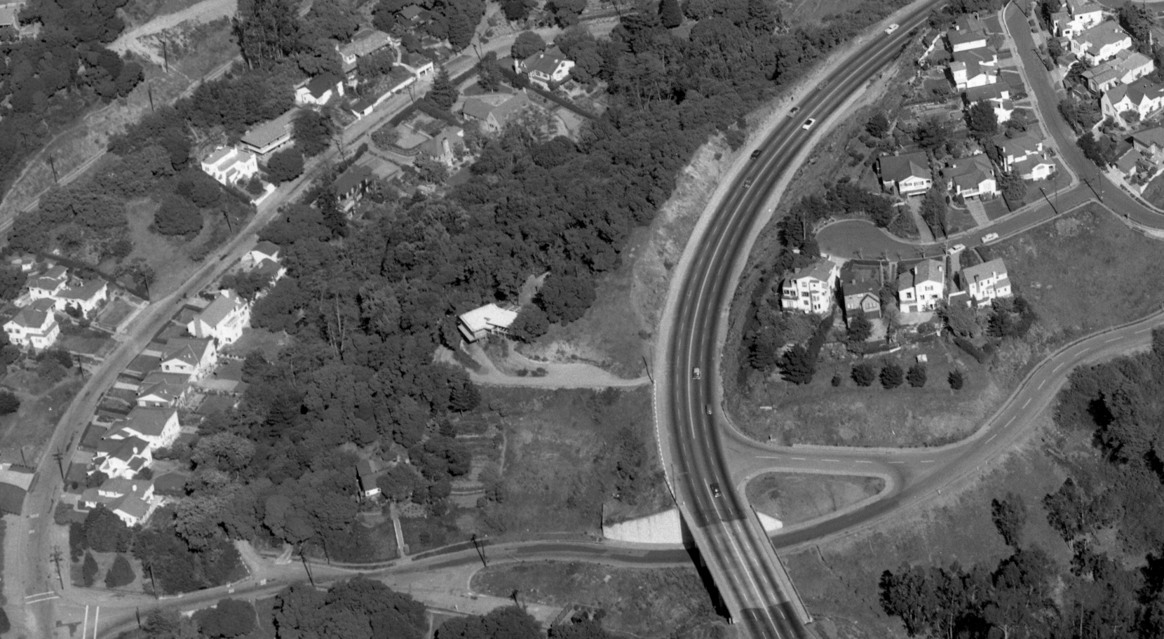
This update will be the first installment of the planning and construction of Highway 24 and BART relative to how it impacted the homes in Chabot Canyon, starting with the western end as shown in this east view from Apr. 8, 1953.
L177-05-Copyright California Department of Transportation, 3301-18, Detail , (Image 1 of 49)

Consider first the homes and land directly in the path of Highway 24 that were necessary to be obtained by the California Department of Public Works, Division of Highways starting in the late 1950s.
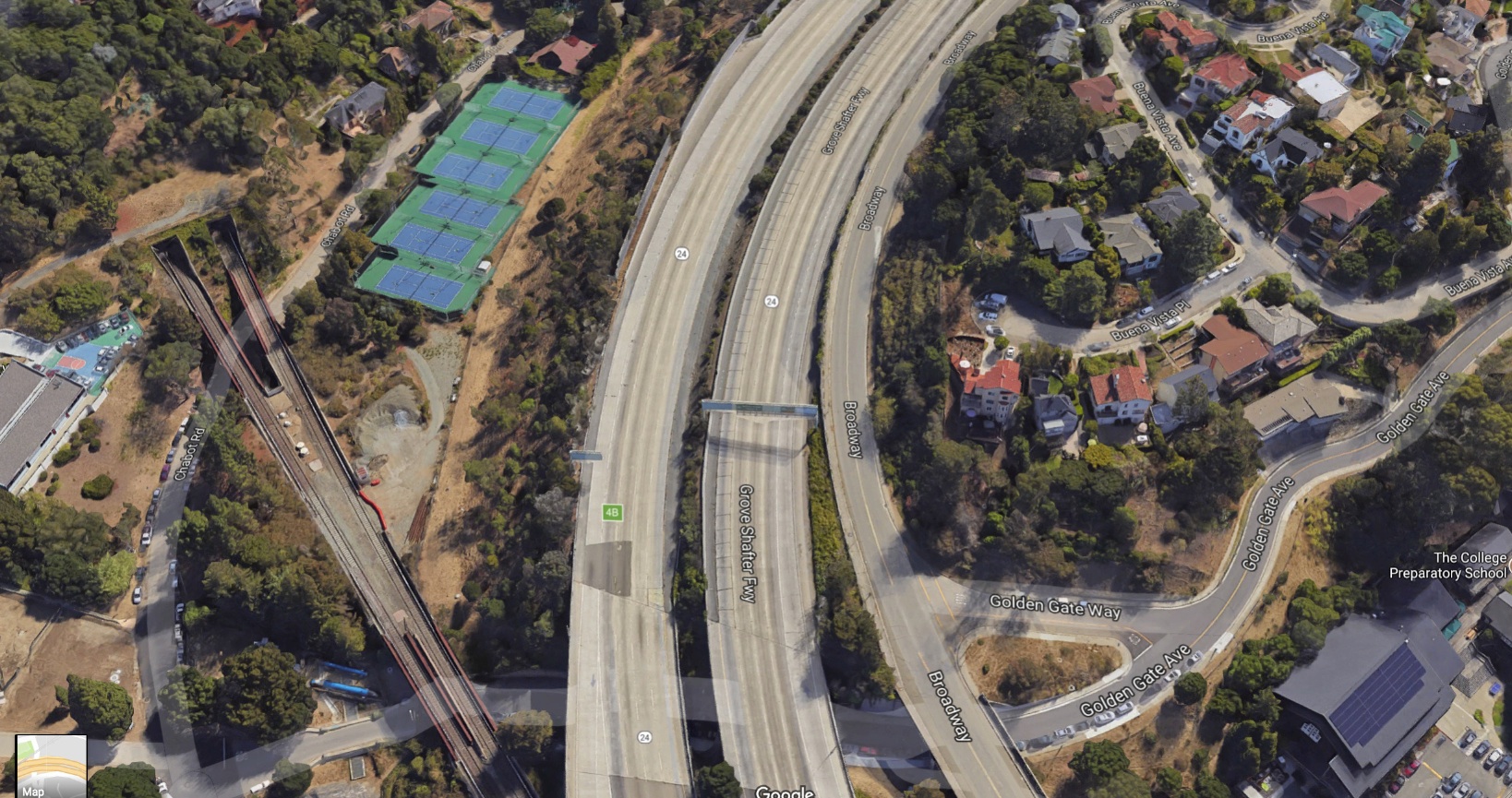
L177-10-Courtesy Google Maps, (Image 2 of 49)
The two homes and the surrounding properties that included two more individually-owned lots can be seen in this east view of Chabot Canyon from Apr. 8, 1953. Key landmarks for this discussion include Broadway or Alameda Route 75, orange arrow, Golden Gate Ave., blue arrow, and Severance Ave., red arrow. The green arrow marks the blockade of the stub of road that was originally Severance Ave., the history of which will be explained shortly.
L177-15-Copyright California Department of Transportation, 3301-18, Detail, (Image 3 of 49)
This map of the Rockridge and Chabot Canyon areas from July 1957 shows how Golden Gate Ave. and Severance Ave. were once separate roads across the canyon. Golden Gate Ave. received an underpass under the extension of Broadway, but Severance Ave. did not and was eventually shortened before it met Broadway from the north.
L177-20-Copyright California Department of Transportation, A-529.0 , (Image 4 of 49)
This eminent domain diagram from Aug. 1958 with up-to-date road names of the period will be the source of the diagram that follows.
L177-25-Copyright California Department of Transportation, A-539.0, (Image 5 of 49)
A detail from the diagram in L177-25 shows the four lots in question with their Division of Highways’ designations. Note that one of two roads previously called Laurel Rd. in L177-20 has been renamed Severance Ave. The first lot, 21276 or no. 5806 Golden Gate Ave., will be presented first.
L177-30-Copyright California Department of Transportation, A-539.0, Detail, (Image 6 of 49)
Number 5806 was an empty lot when an assessment of the land was undertaken on Aug. 31, 1959. This northwest view was taken from the highest point of the parcel, with a view of Broadway and the Golden Gate Ave. overpass to the left, and the fields adjoining Chabot Elementary School to the right.
L177-35-Copyright California Department of Transportation, Binder 5476, (Image 7 of 49)
Looking down from the highest part of the parcel onto Golden Gate Ave. in Aug. 1959 shows the level area that was proposed for a building site that was never developed. The road in the background with the parked car is the remaining stub of the original Severance Ave., the black barrier in place.
L177-40-Copyright California Department of Transportation, Binder 5476, (Image 8 of 49)
Finally, a northeast view from Golden Gate Ave. toward the home at no. 20 Severance Ave. or lot 21277.
L177-45-Copyright California Department of Transportation, Binder 5476, (Image 9 of 49)
The valuation of this lot was compiled based on three recent sales of the lots indicated below; VR-62.1 adjacent to 111 Roble Rd., purchased for 6250 dollars by the adjacent owner Leo R. Pedemont from the SN on Sept. 22, 1958; VR-55.2 at 5771 Buena Vista Ave., purchased for 5500 dollars by Roscoe Nanninga from Elizabeth Kherlein on Sept. 2, 1958; and VR-33.1 on Brookside Ave., purchased for 3300 dollars by Charles Fisher from developer Donald Rheem on Mar. 27, 1959.
L177-50-Copyright California Department of Transportation, Binder 5476, (Image 10 of 49)
For the next two lots, this diagram from Aug. 1958 of the parcels of interest and recent comparable sales to set valuations will be used.
L177-55-Copyright California Department of Transportation, A-539.0, (Image 11 of 49)
The lots to be discussed next are colored in and numbered as 21275, or no. 5820 Golden Gate Ave., and 21277, or no. 20 Severance Ave.
L177-60-Copyright California Department of Transportation, A-539.0 Detail, (Image 12 of 49)
A more detailed diagram from July 1959 of the two lots will be derived from this document.
L177-65-Copyright California Department of Transportation, A-539.2, (Image 13 of 49)
This detail from L177-65 from July 1959 shows that both lots have homes. For some unknown reason, here Severance is called “road” and not “avenue”.
L177-70-Copyright California Department of Transportation, A-539.2 Detail, (Image 14 of 49)
This east view of Chabot Canyon is presented again to show what the two homes looked like on Apr. 8, 1953.
L177-75-Copyright California Department of Transportation, 3301-18, Detail, (Image 15 of 49)
First to review 21275 or no. 5820 Golden Gate Ave., here shown in a southeast view from Reata Pl. across the fields adjoining Chabot Elementary School in 1961.
L177-80-Copyright California Department of Transportation, Binder 5668, (Image 16 of 49)
A northeast view of no. 5820 Golden Gate Ave. from the road, 1961. The home was noted to be 22 years old at this time.
L177-85-Copyright California Department of Transportation, Binder 5668, (Image 17 of 49)
A close-up east view of the front of no. 5820 Golden Gate Ave, 1961.
L177-90-Copyright California Department of Transportation, Binder 5668, (Image 18 of 49)
Two rear views with patio of no. 5820 Golden Gate Ave. from 1961.
L177-95-Copyright California Department of Transportation, Binder 5668, (Image 19 of 49)
The driveway from Golden Gate Ave., top left, also shows the bridge over Temescal Creek. The driveway led to a garage and, seen here to its right, a carport. The bottom right is a southern view of no. 5820 Golden Gate Ave.
L177-100-Copyright California Department of Transportation, Binder 5668, (Image 20 of 49)
The appraisal of no. 5820 Golden Gate Ave. from 1961.
L177-105-Copyright California Department of Transportation, Binder 5668, (Image 21 of 49)
The summary sheet of findings of no. 5820 Golden Gate Ave. from 1961 is shown above.
L177-110-Copyright California Department of Transportation, Binder 5668, (Image 22 of 49)
Part of the enhanced value of the property was its landscaping, and the highway district carefully evaluated the plantings in its appraisal.
L177-115-Copyright California Department of Transportation, Binder 5668, (Image 23 of 49)
The property at 20 Severance Ave., lot 21277, presented the biggest challenge of any of the homes in Chabot Canyon based on its lot size, sub-dividing potential, and landscaping. Southwest view.
L177-120-Copyright California Department of Transportation, Binder 5668, (Image 24 of 49)
The home at 20 Severance Ave. was stated to be 12 years old in 1961. Gail Lombardi added that the building permit no. B23555 is dated October 18, 1948, listing Clarence B. Coleman as the owner, J. T. Coleman of Alameda as the builder, and Paul Overmire in San Francisco as the architect, and describes the house as a one-story, 5-room residence with a redwood rustic exterior. The cost of construction was $12,000. South view from Camino Real in Berkeley.
L177-125-Copyright California Department of Transportation, Binder 5668, (Image 25 of 49)
The next several images will pan across the altered west-facing side of the property at 20 Severance Ave. from 1961, proceeding from the south-facing to north-facing side.
L177-130-Copyright California Department of Transportation, Binder 5668, (Image 26 of 49)
The large windows and internal tropical garden come into view ...
L177-135-Copyright California Department of Transportation, Binder 5668, (Image 27 of 49)
... seen here in detail ...
L177-140-Copyright California Department of Transportation, Binder 5668, (Image 28 of 49)
... and finally to the north-facing side.
L177-145-Copyright California Department of Transportation, Binder 5668, (Image 29 of 49)
Two views of the rear of 20 Severance Ave, 1961.
L177-150-Copyright California Department of Transportation, Binder 5668, (Image 30 of 49)
On the left, a southwest view down Broadway shows the first of two driveways to 20 Severance Ave., this one just before or east of the no left turn sign. On the right, the end of this driveway. Both images from 1961.
L177-155-Copyright California Department of Transportation, Binder 5668, (Image 31 of 49)
To enter the second driveway from Golden Gate Avenue, in this image heading south just at the Temescal Creek crossing, Severance Ave. was accessed by making a sharp left at the mailbox and white fence.
L177-160-Copyright California Department of Transportation, Binder 5668, (Image 32 of 49)
Four views from 1961 of the second driveway accessed via Severance Ave., more akin to a private roadway.
L177-165-Copyright California Department of Transportation, Binder 5668, (Image 33 of 49)
The indoor tropical garden in 1961, seen from the outside of the home, left, and from the inside entrance, right.
L177-170-Copyright California Department of Transportation, Binder 5668, (Image 34 of 49)
Two images from 1961 of the living room of no. 20 Severance Ave. suggest the sweeping view of San Francisco, left, and what the appraiser called the Swedish fireplace, right.
L177-175-Copyright California Department of Transportation, Binder 5668, (Image 35 of 49)
Here, the appraisal and the first of three pages of a summary of the parcel are presented. The reference to Tunnel Rd. actually refers to the extension of Broadway to the Caldecott Tunnel, or Alameda 75, not the actual Tunnel Rd.
L177-180-Copyright California Department of Transportation, Binder 5668, (Image 36 of 49)
The second and third pages of the parcel summary are presented here. Clearly, no. 20 Severance Ave. was by a large margin the most highly valued property east of Golden Gate Ave. in Chabot Canyon circa 1960. Much of that value was in the potential to subdivide the property into three additional lots.
L177-185-Copyright California Department of Transportation, Binder 5668, (Image 37 of 49)
The summary sheet of findings of no. 20 Severance Ave. from 1961, left, and a diagram of the entire property, right are shown. The designation of Tunnel Rd. actually refers to the extension of Broadway to the Caldecott Tunnel, or Alameda 75.
L177-190-Copyright California Department of Transportation, Binder 5668, (Image 38 of 49)
The cost approach to derive the value of the property is presented here. This complex and carefully determined analysis indicated that the total value of the property was split 50-50 as home-land.
L177-195-Copyright California Department of Transportation, Binder 5668, (Image 39 of 49)
As painful as the process must have been for the property owners, the next set of documents exemplify the rigorous and thoughtful effort that went into the appraisal of the properties necessary to acquire for the construction of Highway 24.
L177-200-Copyright California Department of Transportation, Binder 5668, (Image 40 of 49)
As with no. 5820 Golden Gate Ave., the list of landscape inventory of no. 20 Severance Ave. was also extensive.
L177-205-Copyright California Department of Transportation, Binder 5668 , (Image 41 of 49)
Details, details, details ...
L177-210-Copyright California Department of Transportation, Binder 5668, (Image 42 of 49)
Finally the last property, starting with this diagram from July 1958 from which a detail will be provided next.
L177-215-Copyright California Department of Transportation, A-539.2, (Image 43 of 49)
A detail showing parcel 21278 or no. 40 Severance Rd. The residence on the property does not show up in the 1953 oblique aerials since it was said to be 6 years in 1960.
L177-220-Copyright California Department of Transportation, A-539.2 Detail, (Image 44 of 49)
Front view of no. 40 Severance Ave. from 1960, this being the north-facing side the home outline shown in L177-220.
L177-225-Copyright California Department of Transportation, Binder 5660 , (Image 45 of 49)
Rear view or south-facing view of no. 40 Severance Ave, 1960. Temescal Creek is prominent as it passed to the north of Severance Ave.
L177-230-Copyright California Department of Transportation, Binder 5660 , (Image 46 of 49)
A view of the flagstaff patio from 1960.
L177-235-Copyright California Department of Transportation, Binder 5660 , (Image 47 of 49)
The appraisal, parcel summary and cost analysis for no. 40 Severance Rd. from 1960 is presented here. Again, a very valuable property.
L177-240-Copyright California Department of Transportation, Binder 5660, (Image 48 of 49)
So Severance Ave. is no more. Although planning and utilizing eminent domain by the Division of Highways preceded the final engineering report establishing a route for BART, the latter got started relatively early on the East Bay Hills tunnel. How that impacted the homeowners in the canyon is up next.
L177-245-Copyright California Department of Transportation, 3301-18, and Google Maps, (Image 49 of 49)