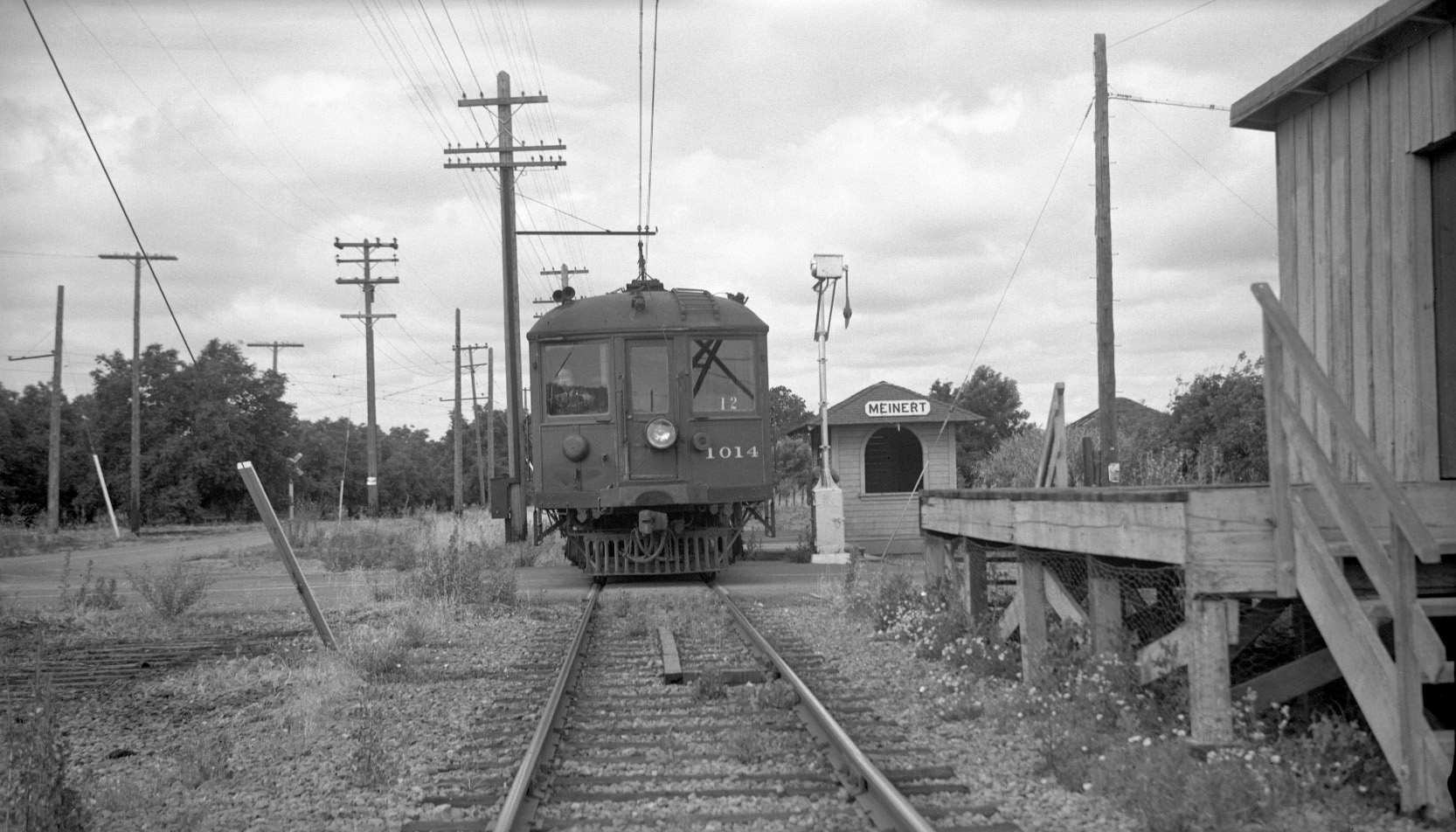
Meinert Junction I – The Shelter and the Vestige of Walwood

With one week of regular passenger service remaining, Dudley Thickens stood just east of Oak Grove Rd. to catch SN 1014 at the Meinert shelter, southwest view, June 22, 1941. For this update, note the remains of the railroad ties indicating a previous second mainline track, left foreground, and the vestige of the Walwood Branch, left background.
L115-05-Dudley Thickens Photo, Courtesy BAERA, Western Railway Museum Archives, 85633sn , (Image 1 of 12)

According to Ira Swett’s “Sacramento Northern”, the Walwood Branch opened June 15, 1911, here seen diverging from the mainline in the background of this wedding party southeast view from that year. Note the presence of two tracks on the mainline in the foreground. Clearly this image shows a different position and larger shelter than the one in L115-05.
L115-10-Courtesy BAERA, Western Railway Museum Archives, 90560sn , (Image 2 of 12)

During Walwood passenger service from 1911-1916, the Meinert shelter was east of Oak Grove Rd., not west as in L115-05. In this northeast view from Apr. 23, 1916, SN 1017 is on the mainline, and SN 1011 on the Walwood Branch. The timetable is a reminder that Walwood trains originated in Concord. Ref: Top, Charles Gselle Photo, Moreau Collection, 82396sn. Bottom, Detail from June 21, 1915 timetable.
L115-15-Courtesy BAERA, Western Railway Museum Archives , (Image 3 of 12)

There was a wye at Meinert Junction in the 1910s, but no images have been found to substantiate this. The yellow circle shows the junction in this 1914 map, with the Walwood Branch identified in its proximal portion by the orange arrows. Note the spelling of “Mienert”. Ref: Weber's CCC 1914 G4363.1914.W4_0005.
L115-20-Courtesy Earth Sciences and Map Library, University of California, Berkeley , (Image 4 of 12)

Outlines of the wye can be seen in the 1939 aerial, the blue arrow showing the east arm used by passenger trains and freight, and the brown arrow the west arm presumably used for freight. Only the west arm remained in 1958. For more about the Walwood Branch, see http://www.wplives.org/sn/walwood.html. Ref: left, USDA AAA Western Division 1939-7-25_BUU-280-64; right, CCC Planning Department, 1958.
L115-25-Courtesy Contra Costa County Historical Society , (Image 5 of 12)

No images have been found to determine when the east arm of the Walwood Branch wye was removed, or when the smaller shelter seen in this southwest view from 1941 replaced the larger one that had existed near the east arm. Note the stopped train blocks Oak Grove Rd. completely to load and discharge passengers.
L115-30-Sappers Collection, Courtesy BAERA, Western Railway Museum Archives 85606sn, (Image 6 of 12)

The only images of the western arm of the wye that have been found are from two mid-1950s BAERA excursions, here shown the first with MW 302, west view from May 2, 1954. As noted previously, there is no evidence that passenger trains used this arm during the Walwood Branch era, and there are no images with freights. Next explores what can be documented.
L115-35-Sappers Collection, Courtesy BAERA, Western Railway Museum Archives 85607sn, (Image 7 of 12)

The end of the western arm of the wye is shown here in an north view from May 2, 1954. The water tower in the background does not match the one that the SN constructed near the freight sheds east of Oak Grove Rd., and is further south of that structure.
L115-40-Dudley Thickens Photo, Courtesy BAERA, Western Railway Museum Archives 85602sn, (Image 8 of 12)

An imperfect composite from the same excursion with MW 302 from May 2, 1954, north view. The edge of BAERA image 86164sn was added to the left side of the 86167sn to complete the structure in the background that fortuitously lined up in both photos.
L115-45-Dudley Thickens Photos, Courtesy BAERA, Wesern Railway Museum Archives, 86167sn, 86164sn, (Image 9 of 12)

Now the second BAERA excursion of note, the last during SN overhead electric operation on the south end, Jan. 13, 1957. SN 1005 and SLU 751 are captured at the grade crossing in this east view. The sign at the Minert Rd.-Oak Grove Rd. junction indicates that it is 3 miles to Concord.
L115-50-JG Graham Photo, Courtesy BAERA, Western Railway Museum Archives, 85648sn, (Image 10 of 12)

SN 1005 and SLU 751 as they fill Minert Rd. on Jan. 13, 1957, northeast view. The water tower and produce sheds on the east side of Oak Grove Rd. will be the topic of the next update.
L115-55-Richard Kampa Photo, Courtesy BAERA, Western Railway Museum Archives, 58310sn, (Image 11 of 12)

One day after the last photographed freight navigated the SN Walnut Creek to Concord section, this southwest view from June 6, 1964 was taken east of Oak Grove Rd. It shows the initial work to extend David Ave. to the Oak Grove Rd. No sign yet of the transformation of this section to the BART test track that followed shortly after.
L115-60-Courtesy BAERA, Western Railway Museum Archives, 85646sn, (Image 12 of 12)