Lining Up the Trees – Yorkshire to Hawthorne

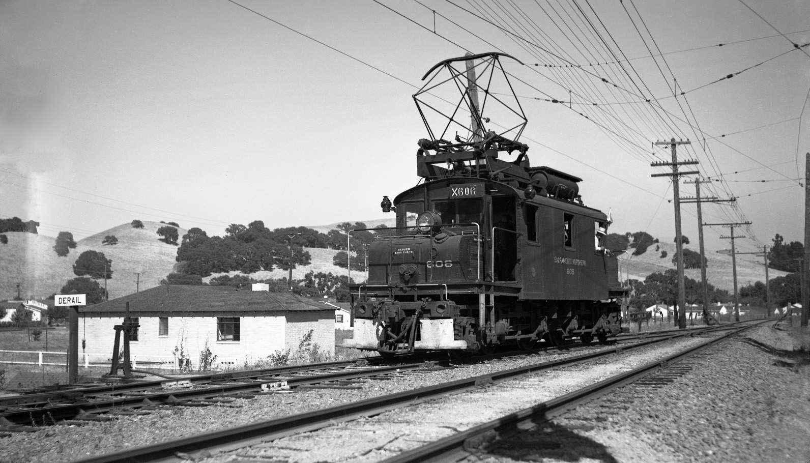
This east view of east Lafayette circa 1940 shows SN 606 at the end of the spur or siding at the Lafayette station area. The return to a single track began just to the west of the future site of Yorkshire Court. Good view of derail mechanism to prevent cars from rolling onto main line. Assigning the placement of these images will require lining up the trees on the hills.
L63-05-Paul Smith Photo, Courtesy BAERA, Western Railway Museum Archives, 67911sn, (Image 1 of 13)

The significant development of the east loop shown via two oblique aerial views from 1946, left, and undated 1940s, right, respectively. Green dot, Yorkshire Ct., Ridge Rd. intersection; red dot, intersection of Hawthorne Ave. (now Dr.) and Hawthorne Ln. (now Old H. Rd.); gold and blue dots are two intersections of Moraga Blvd. and Victoria Ave; yellow arrows, SN right-of-way, with long arrow corresponding to position of SN 606 in L63-05.
L63-10-Contra Costa County Historical Society, Detail 7348, Left, 7349, Right, (Image 2 of 13)

The Yorkshire Ct, Hawthorne Ave. area is compared in aerials from 1939 to 1958 to reveal the change in development for the area. Annotated version follows. Refs. left, USDA AAA Western Division Laboratories BUU-280-102, Jul. 25, 1939; right, CCC Planning Department 1958, CCCHS 13534. Both details.
L63-15-Courtesy East Bay Municipal Utility District and Contra Costa County Historical Society, Deta, (Image 3 of 13)

Annotated version of L63-15 showing key roads for this discussion. Yellow arrow, SN right-of-way corresponding to position of SN 606 in L63-05. The cluster of trees encircled by the orange line will be used as a reference.
L63-16-Courtesy East Bay Municipal Utility District and Contra Costa County Historical Society, Deta, (Image 4 of 13)

Bill McClosky took this photo circa 1941, north view, to document the progress of the construction of his new home on Yorkshire Ct., the latter and Ridge Rd. also new. A good view of the right-of-way, showing the end of the double-track section shown in L63-05, and the homes along Moraga Blvd. and Victoria Ave. to the north.
L63-20-Bill McClosky Photo, Courtesy Lafayette Historical Society, (Image 5 of 13)

Same view, now circa 1942, Bill McClosky‘s north view shows his completed home, SN block signals under the oak tree to the left, or northwest, and extremely fine detail of the Lafayette hills toward what is today Briones Regional Park. Examine the hill profile toward the upper right of the image, and proceed to L63-30.
L63-25-Bill McClosky Photo, Courtesy Lafayette Historical Society, (Image 6 of 13)

The value of images such as L63-25 comes into play in this circa 1952 north image of SN 661 at the tail end of a freight. The location would be difficult to pinpoint without the hill profile from L63-25, allowing placement of the homes in the background along Moraga Blvd.
L63-30-Norman Smith Photo, Courtesy BAERA, Western Railway Museum Archives, 55551.3sn, (Image 7 of 13)

Turning our attention east, this image from Apr. 4, 1939 matches very closely to the image in L63-05, but here SN 1017 is seen more easterly from an earlier date based on the unfinished nature of the roofs of the homes. The tree arrangement in this image becomes important for locating other images starting with L63-40.
L63-35-Ted Wurm Photo, Paul Smith Collection, Courtesy BAERA, Western Railway Museum Archives, (Image 8 of 13)

This northeast image from Jun. 18, 1939 of SN 1012 brings us closer to Hawthorne Ave. The latter is the narrow dirt path marked by the sign in the background, its termination by the right-of-way out of the picture. The oddly shaped tree with the single protrusion, upper right, and the next isolated lollipop-shaped one along the ridge guide us to L63-45.
L63-40-Wilbur C Whittaker Photo, Courtesy Tom Gray and Garth Groff, (Image 9 of 13)

Charley Savage and Wilbur Whittaker were both in Lafayette on Jun. 18, 1939 based on several images. This northeast view with SN 1015 reveals the lollipop-shaped tree, seen at the left margin, SN block signals, and the cluster of oaks corresponding to those encircled by the orange line in L63-16. The homes are obscured by train and tree, but next ...
L63-45-Charles Savage Photo, Courtesy BAERA, Western Railway Museum Archives, 10178sn , (Image 10 of 13)

This east view of SN 1009 from Jul. 14, 1940 shows one of the earliest homes along Hawthorn Ln., now called Old Hawthorne Road. The ridge line of Snake Hill is visible in the background, just above the train.
L63-50-Wilbur C Whittaker Photo, Courtesy Tom Gray and Garth Groff, (Image 11 of 13)

Same east view of Hawthorne Ln., now with SN 670, circa 1952. More homes, more vegetation, but Snake Hill is still visible from the ground.
L63-55-Norman Smith Photo, Courtesy BAERA, Western Railway Museum Archives, 55551.4sn, (Image 12 of 13)

A north view of east Lafayette, with a three-car train with SN 1017 and SN 1014 separated by trailer SN 224 from July 22, 1940. Look at the features reviewed in this section, and decide for yourself as to the location of this image.
L63-60-Wilbur C Whittaker Photo, Courtesy Arnold Menke and Garth Groff, (Image 13 of 13)