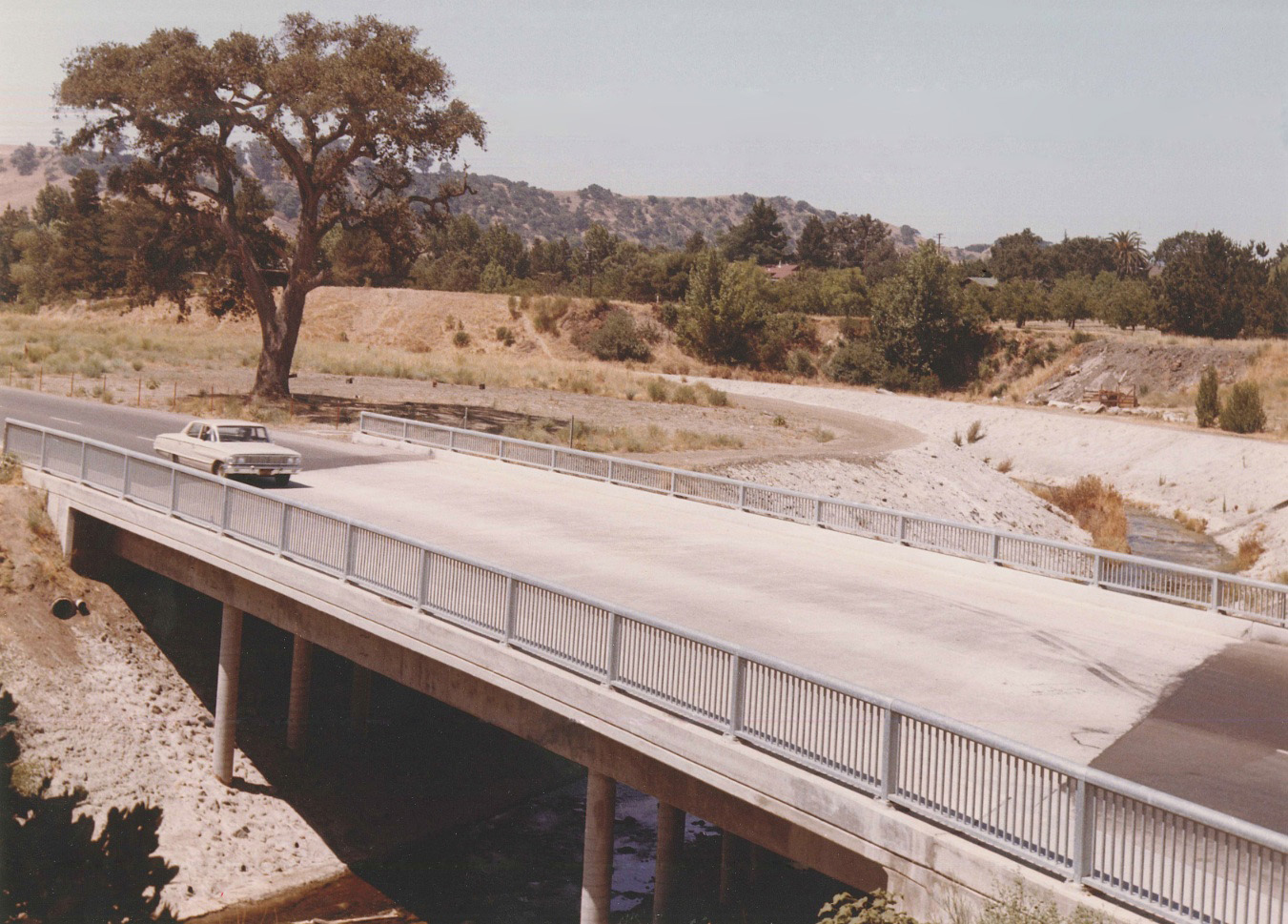
Las Trampas Creek Crossing

It is 1964, taking a drive north on Olympic Blvd. to Walnut Creek in this west view. The crossing of Las Trampas Creek includes the old oak tree that had marked the SN right-of-way back half a century.
L87-05-Courtesy Planning and Engineering Divisions, City of Walnut Creek , (Image 1 of 11)

The old oak allows this scene of a late 1930s west view of east-bound SN 1007-SN 224, south-end car, north-end passenger car duo to mark this spot that sits just to the southwest of I-680 today.
L87-10-Dudley Thickens Photo, Courtesy BAERA, Western Railway Museum Archives, 4329sn, (Image 2 of 11)

Viewed from the air, the enormity of the conversion of the right-of-way to road and channelization of the creek undertaken prior to 1964 can be appreciated. Full Refs: Left, Detail of California of Transportation 2481-2 from Mar. 3, 1952; right, Greenwood and Associates Photo, Panel 4 of 51, Nov 27, 1968.
L87-15- Copyright California Department of Transportation and Planning, City of Walnut Creek, (Image 3 of 11)

For completeness sake, two views of the west side of the SN steel overpass, this one a north view of a two-car, west-bound passenger train from Feb. 21, 1937 ...
L87-20-Dudley Thickens Photo, Courtesy BAERA, Western Railway Museum Archives, 71497sn, (Image 4 of 11)

... and the second view of the west side of the steel overpass also of a two-car passenger train heading west, south view, July 4, 1938. Both this image and the previous one highlight the lack of development of this area prior to WWII.
L87-25-Dudley Thickens Photo, Courtesy BAERA, Western Railway Museum Archives, 60018sn, (Image 5 of 11)

From L87-15, housing development near the creek crossing was in full swing, confirmed here by this west view from a BAERA-sponsored excursion with MW 302 from Nov. 29, 1953.
L87-30-Victor DuBrutz Photo, Courtesy BAERA, Western Railway Museum Archives, 78497sn, (Image 6 of 11)

Aside from rail fan excursions, the railway line only handled freight in the 1950s, here a north view of west-bound SN 661 and haul.
L87-35-Dudley Thickens Photo, Courtesy BAERA, Western Railway Museum Archives, 4603sn, (Image 7 of 11)

Reg McGovern road the rails in the early 1950s, and took this unique view of the crossing highlighting the rugged nature of the wall of the creek. The mile 26 marker tells us the distance to San Francisco, and the 66 corresponds to the remaining distance to Sacramento, although the latter intended meaning needs to be confirmed.
L87-40-Reginald McGovern Photo, Courtesy Reginald McGovern, (Image 8 of 11)

Here a west view of Las Trampas Creek at Olympic Boulevard as work began Apr. 19, 1963.
L87-45-Courtesy Planning and Engineering Divisions, City of Walnut Creek, (Image 9 of 11)

A south view of the crossing one week later, Apr. 29, 1963.
L87-50-Courtesy Planning and Engineering Divisions, City of Walnut Creek , (Image 10 of 11)

Olympic Blvd. is taking shape, here a south view as the new road creek overpass is in the works, Nov. 05, 1963. A big assist from Andy Smith of the Walnut Creek City Planning Division for this update.
L87-55-Courtesy Planning and Engineering Divisions, City of Walnut Creek , (Image 11 of 11)