From Hay to Golf, The Final Approach to Clyde

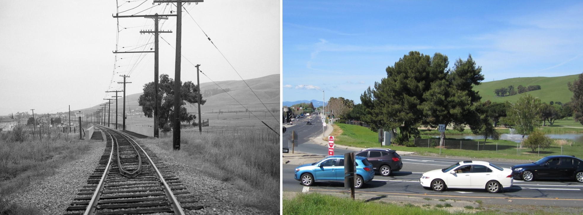
A north view at Ohmer from the Arnold Industrial Highway overpass in the spring of 1957 just after abandonment of the Oakland to Lafayette section compared to a 2016 view approximated by climbing the north hill of Highway 4.
L151-05-EK Muller Photo, Courtesy BAERA, WRM Archives, 94641sn, (Image 1 of 11)

SN 1007 and motorized trailer make a quick stop at Ohmer circa 1940. This train is heading to Oakland, not Clyde, but this northeast view frames the background to be expected in this part of the very north end of Concord.
L151-10-Wilbur Whittaker Photo, Courtesy Tom Gray Collection, (Image 2 of 11)

George Russell’s circa 1929 north view from the level of the precursor to the Arnold Industrial Highway or Route 4 shows the Bay Point and Clayton right-of-way and Diablo Creek converging on Clyde from the east and scattered farms to the west. Ref: API 563_6_BOX 59113
L151-15-George Russell Photo, Courtesy California State Lands Commission , (Image 3 of 11)

A west view along the Arnold Industrial Highway on Aug. 3, 1944 provides the site of the future Diablo Creek Golf Course once the Navy took over and offered this spot to the city of Concord. The highway overpass is on the left edge of the image, the Clyde Hotel along the right edge. Ref: RG 181 1944 N1-13NT1-32Serial38436 083144
L151-20-US Navy Photo, Courtesy the National Archives of San Francisco, (Image 4 of 11)

This agricultural map dated from 1939, but showing names from the pre-1931 era, marks the territory between Ohmer and Clyde as being primarily for hay or grain fields, grazing land, and cultivation of “Toyan”, or more properly, Toyon or Christmas berry or California holly. Ref: G4363.C6J1 1939 .C6
L151-25-Courtesy Earth Sciences and Map Library, University California, Berkeley, Detail, (Image 5 of 11)

Even during the period of oversight by the Navy, this mid-1956 southeast view from a 1956 excursion with SN 653, the WP open car, and Salt Lake and Utah 751 parlor car confirms the agricultural emphasis of the area.
L151-30-Tom Gray Photo, Tom Gray Photo, (Image 6 of 11)

Two north views comparing the transformation of the terrain from field to golf course taken from the Arnold Industrial Highway overpass, circa mid-1950s with SN 652 on the left, and on Apr. 12, 1964 during the End-of-an-Era excursion led by SN 143 on the right. The golf course clubhouse stands out in the background of the latter.
L151-35-EK Muller Photo, Courtesy BAERA, WRM Archives, 79013sn and Charles Smiley, (Image 7 of 11)

In the left panel, a rare view of a passenger train in this section, here no. 27 composed of SN 1005 and SN 1023, heading for Concord in this southeast view along the county road known today as the Port Chicago Highway. To the right, the same view during the Apr. 12, 1964 End-of-an-Era excursion led by SN 143. Ref: left, Vernon Sappers Collection, 102833sn; right, Vic DuBrutz Photo, 103816sn
L151-40-Courtesy BAERA, Western Railway Museum Archives, (Image 8 of 11)

SN 661 carries a freight loaded with pipe toward Oakland in this circa 1950 north view along the final curve of the Port Chicago Highway prior to reaching Clyde.
L151-45-Tom Gray Photo, Courtesy Tom Gray , (Image 9 of 11)

North of the scene in L151-45 and past the final curve, SN 661 and SN 603 get an assist from an unidentified rear motor to move freight west to Oakland. Note the Clyde Hotel along the left edge of this circa 1950 north view.
L151-50-Tom Gray Photo, Courtesy Tom Gray, (Image 10 of 11)

Two north views with the signature stand of trees to the east and a view down the Port Chicago Highway into Clyde to the west. Dudley Thickens photo on the left shows SN 670 and a string of boxcars heading west along fenced-off, Navy-controlled land in Oct. 1951, while the Norman Rolfe photo on the right features SN 143 and the End-of-an-Era excursion as it passes the golf course clubhouse on Apr. 12, 1964.
L151-55-Courtesy BAERA, Western Railway Museum Archives, 4609sn, l, 112910sn, r , (Image 11 of 11)