Bye Bye Berm and other Mysteries

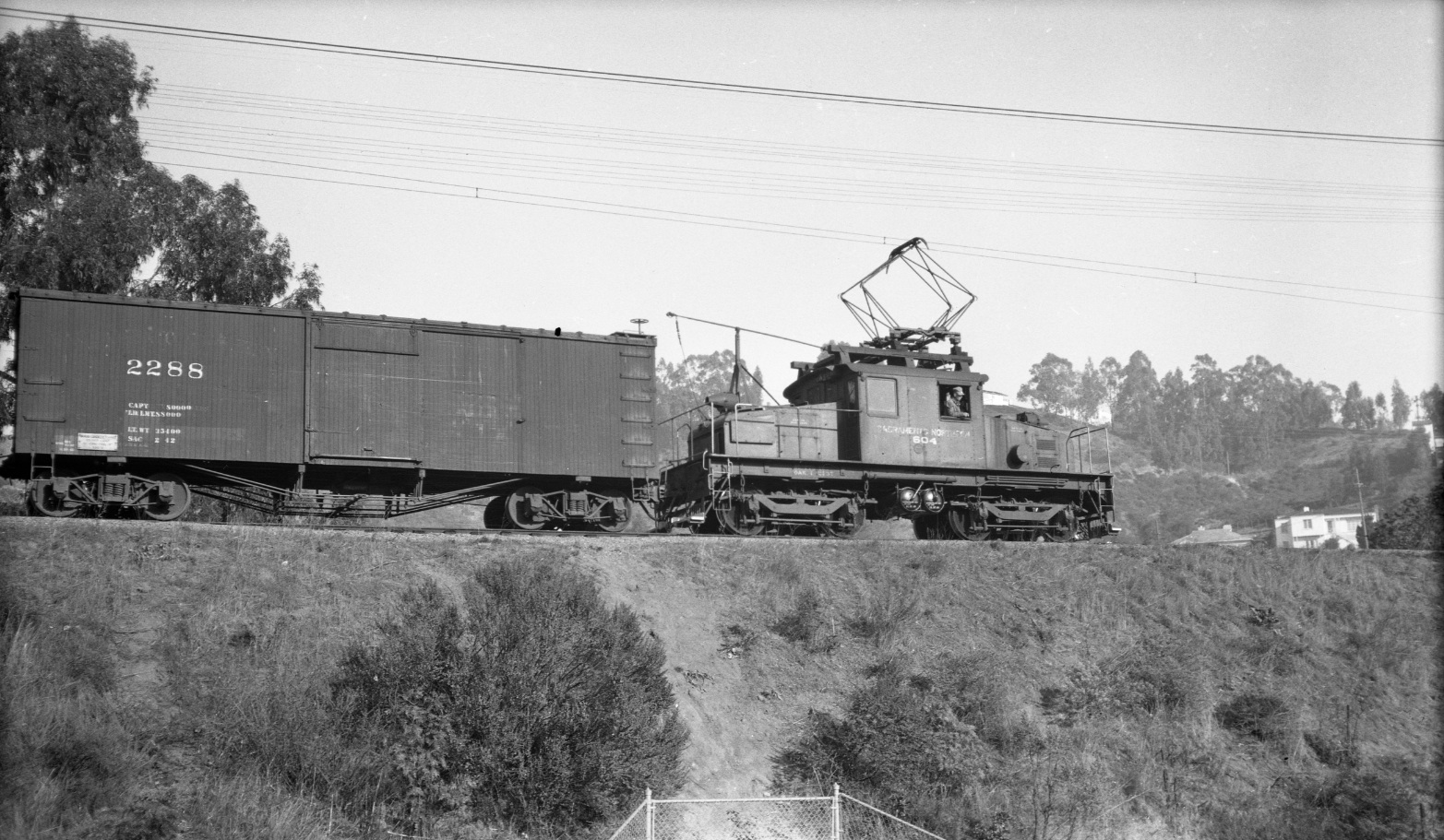
The SN utilized many berms, but the one separating Montclair Elementary and the Montclair Playground was special because of the audience it attracted as trains passed by. East view, SN 604, 1943.
L19-05-Charles Savage Photo, Courtesy Tom Gray , (Image 1 of 22)

An undated close-up east view of the berm with SN 606 at the end of the freight.
L19-06-Railroad Negative Exchange, Courtesy Charles Smiley, (Image 2 of 22)

This aerial of a Feb. 1, 1956, southeast view, defines the berm northwest to southeast, from Thornhill Drive Trestle, bottom right, until the Mountain Boulevard Trestle, top left. The middle portion was primarily a ledge between houses on the western flank and the school to the east.
L19-10-Copyright California Department of Transportation, 4809-7 Detail, (Image 3 of 22)

A north view of the northwest end of the berm with SN 1016 and a three-car train from Feb. 26, 1939. The profile of the ties marks the Thornhill Drive trestle, left. Note the Montclair Library, from 1930, last structure east of the berm, right, and the Montclair Women's Cultural Arts Club, from 1919, on the southeast corner of Thornhill and Mountain, right edge of image.
L19-11-Wilbur C. Whittaker Photo, Courtesy Arnold Menke and Garth Groff, (Image 4 of 22)

This northwest view from Sept. 23, 1953, shows the berm in the opposite orientation relative to L19-10.
L19-15-Public Works Photo, Oakland Cultural Heritage Survey, Oakland City Planning Department , (Image 5 of 22)

The southeast portion shown in this Feb. 1, 1956, northeast view, was somewhat more accessible. The gate seen on the playground side may have permitted access between the playground and the school, but this image doesn’t prove it. However, read on ...
L19-20-Copyright California Department of Transportation, 4809-2 Detail, (Image 6 of 22)

Looking to the northwest in Apr. 1951, SN 670 and its load split the school from the playground.
L19-21-Railroad Negative Exchange, Courtesy Charles Smiley, (Image 7 of 22)

Another view of the southeast portion of the berm. This image was cut-off just south of the gate seen in L19-20, so it cannot address any cross access under the berm. Southeast view, Sept. 23, 1953.
L19-25-Public Works Photo, Oakland Cultural Heritage Survey, Oakland City Planning Department , (Image 8 of 22)

SN 670 is again the center of attention, but this time with the help of two additional motors in this west view from Apr. 12, 1952.
L19-26-Wilbur C. Whittaker Photo, Courtesy Charles Smiley and Garth Groff, (Image 9 of 22)

A northwest image of SN 1015 crossing the Mountain Boulevard trestle in 1940 shows the berm and its relation to present day structures, the Montclair fire station on Moraga Avenue, and the tennis courts in Montclair playground.
L19-30-Charles Savage Photo, Courtesy Tom Gray , (Image 10 of 22)

Alterations to Montclair Elementary and eastern hillside additions provide a potential way to date images from this period. Northwest view, circa 1952.
L19-35-Reginald McGovern Photo, Courtesy Reginald McGovern, (Image 11 of 22)

And moments later, passing over Mountain Blvd., northwest view, 1952.
L19-37-Reginald McGovern Photo, Courtesy Reginald McGovern , (Image 12 of 22)

This southeast view with SN 605 circa 1938 will be compared to the same view circa 1950. Before heading there, note the signature stairway seen on the hill that is still in use today ...
L19-40-Paul Smith Photo, Courtesy BAERA, Western Railway Museum Archive, 54276sn, (Image 13 of 22)

The same view with a SN 654-led freight circa 1950 shows completion of the school yard with an addition of a building. Considering more than a decade has passed relative to L19-40, only a few changes to the hills can be documented.
L19-45-Tom Gray Photo, Courtesy Tom Gray , (Image 14 of 22)

The final Mountain Boulevard SN overpass or trestle opened to traffic on Oct. 8, 1936 according to the Oakland Tribune. The crossing in this undated southeast view with SN 1014 seen in the background lacks the characteristic high walls above rail level as shown in L19-45. More later ...
L19-50-Paul Smith Photo, Courtesy BAERA, Western Railway Museum Archive, 54275sn, (Image 15 of 22)

No pictorial review of the berm would be complete without an image of SN 652 and the last freight run, Feb. 28, 1957, east view.
L19-55-EK Muller Photo, Courtesy BAERA, Western Railway Museum Archive, 45015sn, (Image 16 of 22)

Kathleen DiGiovanni, Librarian, Oakland Public Library and Oakland History Room, asked, "When was the berm removed and what were the details surrounding this event?" North view, west side of the concrete trestle abutment, west side of Mountain Boulevard.
L19-60-Stuart Swiedler Photo, (Image 17 of 22)

The Montclarion newspaper provided the answers. The Oakland Public Library came through, with bound volumes from the late 1950s. This image speaks for itself. Montclarion, Nov. 20, 1957
L19-65-Courtesy Oakland History Room, Oakland Public Library , (Image 18 of 22)

This excellent diagram provides more answers, including confirmation of the existence of the tunnel between the school and the playground. Montclarion, Sept. 23, 1959
L19-70-Courtesy Oakland History Room, Oakland Public Library , (Image 19 of 22)

This clinching piece of evidence informs us that the southeast portion of the berm did not make it into the 1960s. Montclarion, Nov. 4, 1959
L19-75-Courtesy Oakland History Room, Oakland Public Library , (Image 20 of 22)

This east view from Montclair Playground marking the location of the berm is still an impressive site with the Mountain Blvd abutments as a reminder of a time when electric trains rose high above Montclair. Head over to Thornhill and Moraga for a view of a less dramatic, albeit still intact berm.
L19-80-Stuart Swiedler Photo, (Image 21 of 22)

A 1940s freight makes its way over the Mountain Boulevard overpass and heads to Montclair Village, the next destination.
L19-85-Railroad Negative Exchange, Courtesy Charles Smiley, (Image 22 of 22)